Saksena Research Group
Focus Areas


Urban Flooding Open Knowledge Network
The true impact of flooding is dictated not just by the amount of rainfall, but how the physical infrastructure features, such as the roads, buildings, stormwater network, power stations, and water retaining structures are able to collectively absorb shocks produced by the flooding event. Currently, there is no way to forecast infrastructural level flood risk at the national scale even though significant progress has been made in weather forecasting. To enable national scale flood prediction and forecasting, our team at Virginia Tech is collaborating on an NSF-funded project called the Urban Flooding Open Knowledge Network (UFOKN). Our current work for the UFOKN involves developing historical and climate-informed data analytics tools that are critical for providing historical estimates of flood risk across existing infrastructure, identifying locations for future infrastructure planning, and simulating hydrologic and hydraulic models.
Improve flood modeling practices for more accurate, efficient & scalable prediction
Climate change and land development or urbanization is expected to exacerbate both the intensity and frequency of extreme flooding worldwide. As the flood severity rises, there is a growing need to develop flood prediction and alert systems that provide fast and reliable forecasts. Currently, it is extremely difficult to identify how much, when, and where the flooding will occur, which can create uncertainty in evacuation planning and preparation. Through this work, we are developing frameworks to improve the large-scale flood prediction by incorporating more physicality into the numerical flood models which helps in enabling a better estimation of the depth, location, and arrival time of flooding.


Evaluate systemic impacts of flooding on urban infrastructure
Over the last 50 years, flood modeling has evolved significantly through advances in mathematical formulations, satellite-based remote sensing products for model parameterization, optimization tools for model calibration, and availability of high-resolution topographic data. Although the science of flood prediction has evolved significantly through improved data access, there are several knowledge gaps preventing accurate modeling of different physical processes that can impact how flood propagate through complex hydrologic systems. This work directly addresses the issues and challenges with the conventional flood modeling approach, and provides a novel methodology for delineating the individual influence of different hydrosystems on flooding in urban environments.
Large-scale flood modeling using an integrated hydrosystems approach
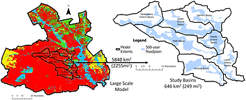
Hurricane-induced flooding poses a significant risk to both life and property especially across urbanized regions with a highly dense population. In this regard, it is important to capture the complex hydrodynamics and quantify the compound nature of Hurricane-induced inland flooding at large scales in an integrated manner. Using a flexible model design and hybrid computational framework, we are building cost-efficient models to help predict unprecedented flood events at large scales in complex urban systems. The new spatiotemporally flexible computational framework developed in this work is first of its kind and has the capability to simulate compound floods across large spatial domains at a hyper resolution and provide near-real time flood depths across complex urban systems.


Comprehensive framework for urban flood modelling
Through this work, we are developing a comprehensive framework that incorporates historical as well as future projected changes in extreme precipitation for assessment of urban floods. The framework involves three components: modeling of historical extreme precipitation including analysis of stationarity/non-stationarity testing, automated IDF curve generation, modeling of extreme precipitation in future climate projections using a Bayesian weighted averaging framework, and distributed urban flood modeling for historical and design precipitation.
Externally Funded Projects

Title:
Sponsor:
Period:
Amount:
Team:
Development of a new Occoquan Watershed Modeling Framework
Northern Virginia Regional Commission
2024 - ongoing
$310,000
PI: Siddharth Saksena (Virginia Tech), Co-PIs: Stanley Grant (Virginia Tech), Megan Rippy (Virginia Tech), Lalit Pal (Virginia Tech)

Title:
Sponsor:
Period:
Amount:
Team:
Landuse impact modeling and assessment for the Occoquan Watershed
Northern Virginia Regional Commission
2024 - 2025
$176,000
PI: Siddharth Saksena (Virginia Tech), Co-PIs: Stanley Grant (Virginia Tech), Megan Rippy (Virginia Tech)

Title:
Sponsor:
Period:
Amount:
Team:
Southern Rivers Updates for Delivery Ratios and Nutrient Targets
Virginia Department of Environmental Quality
2023 - 2024
$79,000
PI: Siddharth Saksena (Virginia Tech), Co-PIs: Clayton Hodges (Virginia Tech), Mark Widdowson (Virginia Tech)
Title:
Sponsor:
Period:
Amount:
Team:
Proto-OKN Theme 1: The Water-Energy Nexus Open Knowledge Network (WEN-OKN)
National Science Foundation
2023 - 2026
$1,000,000
PI: Lilit Yeghiazarian (University of Cincinnati), Co-PIs: Ilya Zaslavsky (UC San Diego), Eric Welch (ASU), Justin Zhan (UCinn), Siddharth Saksena (Virginia Tech)


Title:
Sponsor:
Period:
Amount:
Team:
An integrated framework to quantify and improve the climate change resiliency of combined sewer overflow systems in the Northeast Ohio Regional Sewer District
Ohio Sea Grant Commission (National Oceanic and Atmospheric Administration)
2022 - 2024
$160,000
PI: L Yeghiazarian (University of Cincinnati), Co-PI: Siddharth Saksena (Virginia Tech)

Title:
Sponsor:
Period:
Amount:
Team:
Identification of cost-effective green stormwater infrastructure to mitigate flooding in Houston’s vulnerable communities and improve Galveston Bay fisheries
Texas A&M University/DOC-NOAA
2022 - 2024
$300,000
PI: J Eisma (UT Arlington), Co-PIs: Siddharth Saksena (Virginia Tech), D Coursey (UT Arlington), Dominic Boyer (Rice)

Title:
Sponsor:
Period:
Amount:
Team:
Occoquan Model Development for Fiscal Year 2024
Northern Virginia Regional Commission
2023 - 2024
$119,000
PI: Siddharth Saksena (Virginia Tech), Co-PIs: Stanley Grant (Virginia Tech), Megan Rippy (Virginia Tech)

Title:
Sponsor:
Period:
Amount:
Team:
Identification of Cost-Effective, Climate-Informed Green Infrastructure Adaptations to Reduce Flood Risk in Houston’s Vulnerable Communities
National Oceanic and Atmospheric Administration
2021 - 2023
$299,468
PI: J Eisma (UT Arlington), Co-PIs: D Coursey (UT Arlington), MA Hummel (UT Arlington), Siddharth Saksena (Virginia Tech), Claire Knox (UCF), Dominic Boyer (Rice)

Title:
Sponsor:
Period:
Amount:
Team:
NSF Convergence Accelerator Pilot Phase II: The Urban Flooding Open Knowledge Network (UF-OKN) Delivering Flood Information to AnyOne, AnyTime, AnyWhere
National Science Foundation
Sep 2020 - Aug 2023
$5.3 million (VT: $398,650)
PI: L Yeghiazarian (University of Cincinnati) For full team: https://ufokn.com/team.html
